
post 291/365
The river flows and brings life back to this soil. It tells tales of life in a never-ending flowing pattern of liveliness. Calm and fast-flowing but unsuspecting of the path ahead it flows and ends up in the Mediterranean Sea, where it tumbles with its glorious white droplets of pure life soon to be immersed in uniformity with it as they mend as one.
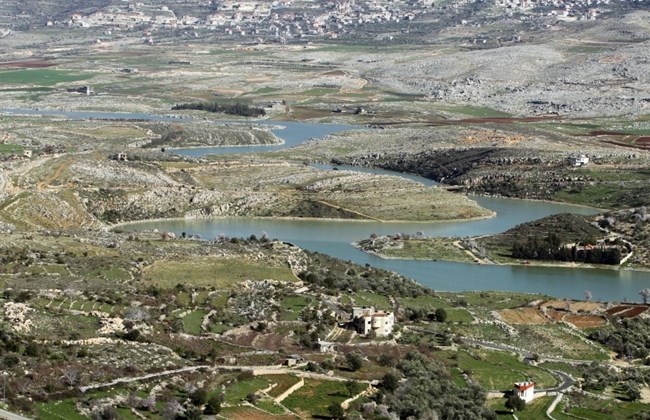
The Litani River moves through spectacular areas of natural, deep gorges, mountains, steep valleys, waterfalls, olive groves and rows of fig trees at every corner.
The Litani River the classical Leontes, Greek for lions, is an important water resource in southern Lebanon and is the chief river of Lebanon. The river rises in a low divide west of Baalbek and flows southwestward through the fertile Beqaa Valley between the Lebanon and Anti-Lebanon mountains. Near Marj’youn it bends sharply west and cuts a spectacular gorge up to 275 meters deep through the Lebanon Mountains to the Mediterranean south of Sidon. Around 170 km in length, the Litani River is the longest river in Lebanon. What makes the Litani River special is that its waters both originate and flow entirely within the borders of Lebanon. It provides a major source for water supply, irrigation, and hydroelectricity both within Southern Lebanon and the bekaa and the country as a whole. The water itself is considered of high quality, though somewhat polluted as it reaches the sea.
The river’s lower course flowing west is known as Qasimiyeh. The Qasmieh-Ras-el-Aïn region, irrigated from the river’s lower reaches from main irrigation canals, to south and north, is one of the largest irrigated areas in the nation, consisting of 32.64 km², shared among 1257 irrigating farmers, who concentrate on citrus crops and bananas.
For the entire stretch of the Qasimiyeh as it flows into the Mediterranean Sea, the Litani River remains nearly parallel to (and about 29 km north of the Palestinian-Lebanese border. 10 km north of Tyre, the river is crossed by the ancient Leontes Bridge, a Roman segmental arch bridge in the vicinity of Nahr Abou Assouad.
The Litani River has 16 tributaries, Including:
On the right riverbank in Bekaa:
- Berdawni River, Chtoura River, Qib Elias River, Saadnayel spring, Amik spring, Khrayzat spring, Machgara spring.
On the left riverbank in Bekaa:
- Yahfoufa River (which feeds the Riyak Valley), Ghzayel River which is the most important because it includes Ras al-Ain spring (Terbol), Faour spring, Ain el-Baida, Faregh River, Chamsine spring and Anjar spring.
All these tributaries flow within a distance of 10 km into the Litani River.
- In southernmost part of the Bekaa Valley, the Litani River receives the water of Ain Zarqa and Ghalleh springs.
- As it exits Bekaa and enters the lower part of its course, the Litani River falls, within a distance of 100 km, from an altitude of 800 meters above sea level. This slope is the steepest.
- In this lower part, the Litani River receives the water of Zraykoun River and Wadi Saluki River.
- The River’s course deviates westward at Al-Khardali bridge, near Beaufort Castle towards Deir Mimas where it is called Qasimiya River” which flows into the Mediterranean Sea.
As early as 1905, early Zionists considered diverting the Litani. Later, it was hoped that the river would be considered as a northern border, but the League of Nations nixed that proposal. Later still, some suggested leasing the water to the young Israeli State. Long after the Israeli borders were set, Israel’s first prime minister, David Ben-Gurion still wanted to see the Litani become part of Israel, and as late as the 1967 war Defense Minister Moshe Dayan was disappointed that the river remained entirely in Lebanese hands. The 1978 invasion of Lebanon itself was interestingly named the Litani River Operation.
In June 1941, the mouth of the river was the site of an attack by British commandos and Australian troops on Vichy French forces that became known as the Battle of the Litani River.
As battles were fought and wars were waged in its name and in the areas it traversed, this river peaceful and indifferent carried through its monumental path to the sea. From this land and to this land it remains, a national symbol of Lebanese fertility and somehow the futile passing of time from its birth in the fertile Bekaa valley to the end of its life on the shores of the Mediterranean Sea.
pictures taken from the internet


